Maps of the Regions and Cities of Japan
Japan is divided into 5 main geographical divisions: Hokkaido, Honshu, Shikoku, Kyushu and Okinawa. The main island of Honshu is further divided into 5 regions: Tohoku, Chubu, Kanto, Kinki and Chugoku. The administrative system is divided as follows: Tokyo To (metropolis); Hokkaido Do (circuit); Osaka Fu, Kyoto Fu (urban prefectures); 43 Ken (prefectures). This system was introduced in 1888, with Tokyo being designated as a metropolis in 1943.
Click on the names of the 9 regions below to go to our sightseeing pages on each. Clicking on the prefectures will take you to their respective official websites. We have linked to English language sites where a decent one is available. Other prefectures provide only a machine-translated version of the Japanese site.
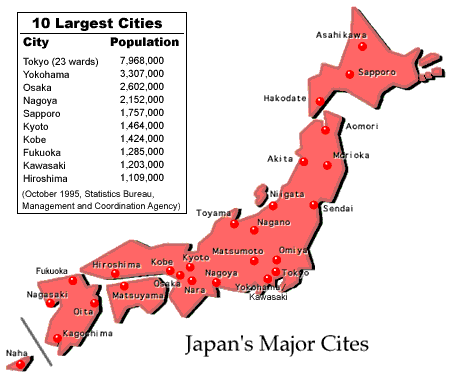
At the time of the October 1, 2010 national census, the population of Japan was 128,057,352. The most densely populated areas are the Tokyo metropolis and its port cities of Yokohama and Kawasaki and the so-called Kansai area, made up of Osaka, Kobe and Kyoto. While the population of the 23 ku (wards) that make up the city of Tokyo is around 8 million, the metropolis is home to almost 30 million people. The population of the Kansai area is around 16 million.
Click on the cities in the map below to go to their official websites. We have linked to English language sites where they are available. Other cities provide only a machine-translated version.

Links
- The Statistics Bureau of the Management and Coordination Agency runs a very informative site.
- A good map service (Japanese only) of the whole country is provided by Mapion.